- Adventure
Walking excursions and hiking routes in Andorra
Nine routes sorted by difficulty, using the official route sheets.
Andorra has trails for almost every level: flat strolls beside an irrigation channel, glacial lakes less than an hour from the car park, and summits above 2,700 metres. Here are nine routes sorted by difficulty, using the official Visit Andorra route sheets wherever they exist, so you can choose with the distance and ascent to hand.
Before you set off, a word on the season: Visit Andorra recommends walking routes above 1,700 metres between late June and late September. If the weather and terrain allow, that window can stretch from May to October. Conditions change quickly in the high mountains, so bring suitable footwear and clothing.
Easy walks
If you are new to hiking, or you want a family route that children will love, start here. These are simple routes, although the time they take varies quite a lot from one to the next.
- Rec del Solà (Andorra la Vella): its 5.13 kilometres have hardly any climb, about 3 metres, because the path follows an old irrigation channel. It starts near Sant Ermengol and passes the parish vegetable gardens and a picnic area with a viewpoint. Along the way, information panels explain how the valley changed through farming, urban growth and adapting to natural hazards. If you walk north along the channel, you reach the oratory of Sant Antoni de la Grella and the Romanesque bridge of Sant Antoni.
- Iron Route (Ordino): it links Llorts with La Cortinada in 4.24 kilometres one way, about 8.4 if you walk back, with 126 metres of ascent. It takes a little over two hours and suits families. The most striking feature is the series of modern iron sculptures that line the whole path, a reminder of the area’s mining and metalworking past. In summer you can visit the Llorts mine, 30 metres deep, and at the end you will find the church of Sant Martí de la Cortinada, with murals from the late 12th century. If this side of the country appeals, there is more in our guide to sacred art in Andorra.
- Camí del Gall (Canillo to Soldeu): this one covers 5.86 kilometres with 285 metres of ascent, from the Canillo cable car car park at 1,535 metres to the CG-2 road near Soldeu. The highest point is El Palinqueró, at 1,805 metres. Follow the red cockerel waymarks. Visit Andorra allows 3 to 6 hours and rates it as suitable for the whole family. The path runs close to the road and often meets it, so you can shorten the walk if you need to. To get back, a bus runs from Soldeu to Canillo every hour on the hour.
Moderate walks
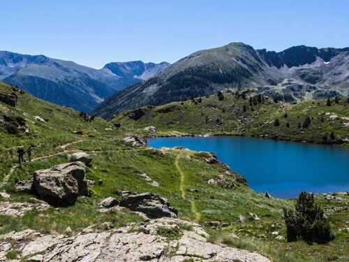
This is where things get interesting. Once you have tried one of the easy routes, you may well want a little more gradient. These three take you to the high-altitude lakes the country is famous for, just like the Pessons lakes, right next to the hotel.
- Tristaina lakes (Ordino Arcalís): a 4.39-kilometre loop with around 210 metres of ascent that starts and ends at the La Coma car park, in the Ordino Arcalís ski area. The full circuit takes about three hours, and the first lake is roughly 40 minutes away, an easy stretch for children. You will see three lakes: the Primer, the Mig and the Més Amunt, which is the largest, at about 2,330 metres, and where swimming is allowed in summer. Near the start stands Arcalís 91, a steel ring by the sculptor Mauro Staccioli. In winter the cirque lies under snow and looks completely different.
- Incles valley and Juclar lake (Canillo): the route begins at kilometre 3 of the road into the Incles valley, past the Baladosa bridge, and climbs 465 metres over 4.57 kilometres to the second Juclar lake. Allow about 2 hours 10 minutes up and 1 hour 40 minutes down, on the same path. Juclar is the largest lake in Andorra, at 21.3 hectares, and the first lake is home to the Pyrenean newt, a species that needs very clean water. The Juclar refuge is staffed and serves meals in summer, so you can spend the night up there. Bear in mind that the valley road closes to traffic in summer, when access is by electric buggy.
- L’Estanyó lake (Ordino): this walk starts at the Canya de la Rabassa car park, at 1,783 metres, inside the Vall de Sorteny Nature Park, the largest protected area in the country according to Rutas Pirineos. It takes around an hour and a half to reach the lake, at about 2,340 metres. The park stands out for its range of plants and has a botanical garden with panels to help you identify them. Once you are up there, only one thing remains: to sit by the water and enjoy the views. If you carry on to the Pic de l’Estanyó, at 2,915 metres, the full route adds up to 11.72 kilometres and about 1,135 metres of ascent, and moves into the very difficult category.
Mountain routes for experienced walkers
These hikes call for high-mountain experience and good fitness. Some sections have steep slopes or exposed passages, so avoid them if you suffer from vertigo or if there is still snow about. Are you up for it?
- Montmalús peak and Colells cirque (Grau Roig): this is our home route. It leaves from the El Cubil car park in Grau Roig and makes a 10.4-kilometre loop with 875 metres of cumulative ascent and about four hours without stops, according to Rutas Pirineos. You pass the first Pessons lake and Coma Estremera lake, reach the summit at 2,781 metres and continue along airy ridges to the Portella de Joan Antoni. In good conditions there are no major technical difficulties, but you will need your hands at certain points. Afterwards, the spa at Hotel Grau Roig, which appears in the MICHELIN Guide, and dinner at La Vaquería or La Marmita are a good way to recover.
- Carroi peak (La Massana to Andorra la Vella): it has no especially tricky sections, but the climb is demanding and relentless. From Sispony it is about 7 kilometres with 900 metres of ascent, with some three hours up and one down according to the Visit Andorra snowshoe route sheet. At the top you get a sheer view down to the centre of Andorra la Vella and Escaldes-Engordany, and on the other side the wild country of the Enclar reserve.
- Casamanya peak (Ordino): its 2,740 metres may look daunting at first, although the official sheet rates it as moderate: 3.75 kilometres and 750 metres of ascent from the top of the Coll d’Ordino road. The opening climb to the Vaques pass is steep, and then you follow a waymarked path. From the summit you can see the Estanyó, the Serrera, Pic de Carroi and Comapedrosa, and with luck griffon and bearded vultures too.
Walking in the mountains in winter
From November to April the snow takes over and these routes play by different rules: the summer terrain is only for people with the right training and equipment. The simplest alternative is snowshoeing, which the hotel lists among its snow activities, with outings to frozen lakes. You can also ask about mushing or ski mountaineering. And if you would like to come back in fine weather next year, our piece on Andorra’s glacial lakes has more ideas for planning your season.